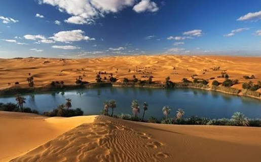
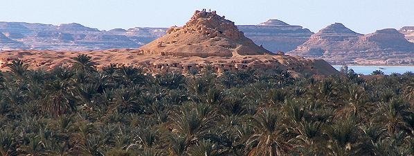
Siwa Oasis, oasis in Maṭrūḥ governorate, western Egypt. It lies near the Libyan frontier, 350 miles (560 km) west-southwest of Cairo. The oasis is 6 miles (10 km) long by 4–5 miles (6–8 km) wide and has about 200 springs. Two rock outcrops provide the sites of the old walled settlements of Siwa and Aghūrmī, which are veritable fortresses. The oasis is inhabited by Berber-speaking Sudanic peoples who live in mud-brick houses at the foot of their former strongholds. Ten miles (16 km) northeast is the small oasis of Al-Zaytūn (Zeitun), and westward a chain of little oases and small salty pools extends for about 50 miles (80 km). Siwa Oasis is extremely fertile and supports thousands of date palms and olive trees. The export of dates and olive oil provide the chief source of income, supplemented by basketry.
A salt pond formed as a result of extracting salt from the lands north of the oasis (Photo: https://beta.sis.gov.eg/)
Geology
The geology of the Siwa Depression and its peripheral mountain belts dates mainly from the Middle Eocene, Late Miocene/Pliocene, and Quaternary periods. The lithology of the existing formation recognizes four main units: Oligo-Miocene carbonate, clay and mudstone, Quaternary alluvium, and sandstone units.
The Siwa area includes many flat terrains and shallow depressions, the lowest of which encompasses the old lake and many natural springs. It is also where humans have gradually settled in local communities practicing mainly agriculture. On a regional scale, Siwa is an integral part of the on-going historical tectonic activities associated with the East Mediterranean.
Those activities have stimulated certain erosional processes, while influenced drainage patterns and contributed to the formation of surface salt deposits. The region's surface, particularly landforms, suffer numerous effects due to surface and subsurface faults, showing mostly in the disruption of drainage patterns throughout. (Ahmed, 2023).
Geosites and geology of Siwa Oasis (After: Ahmed, 2023)
Geomorphology
The northern escarpment of the Siwa Depression is the front of the Marmarica plateau; one of the main geomorphological forms of the Oasis’s physical Depression units. The edge is naturally exposed to erosive weathering impacts, and is visually cut by some gorge valleys. This natural posture has left behind a variety of residual hills, buttes, mesas, chimneys, mushrooms, and other geomorphic features as evidence of erosion in arid areas. A variety of fine geomorphological features, such as weathering cones and processes such as rock-creeping and rock-falling are also observed and defined as prevalent among many of the edges.
Geomorphology
Mainly aeolian and fluvial actions are responsible for the diverse terrestrial features and landforms characterizing Siwa Oasis. It is generally perceived that the surrounding shales of the Western Desert, along with the Marmarika Formation, have both contributed to generate the Siwa Depression as a structural topographical form generally associated with the development of basins. The thermo karstial action has identified and attributed a series of multi-scale landforms in the Siwa Oasis area.
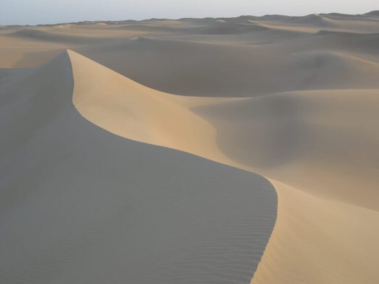
The most common geomorphological features in this depression are: sand dunes, salt pans, sabkhas, and lakes of the Siwa Oasis. Evidently, Sand dunes are the chief
geomorphological form in the Siwa Oasis covering up to 20% of its total area approximately. Wind transports sand from surrounding depressions to form dunes. The main sand dunes surrounding Siwa Oasis is Bir Wahed.
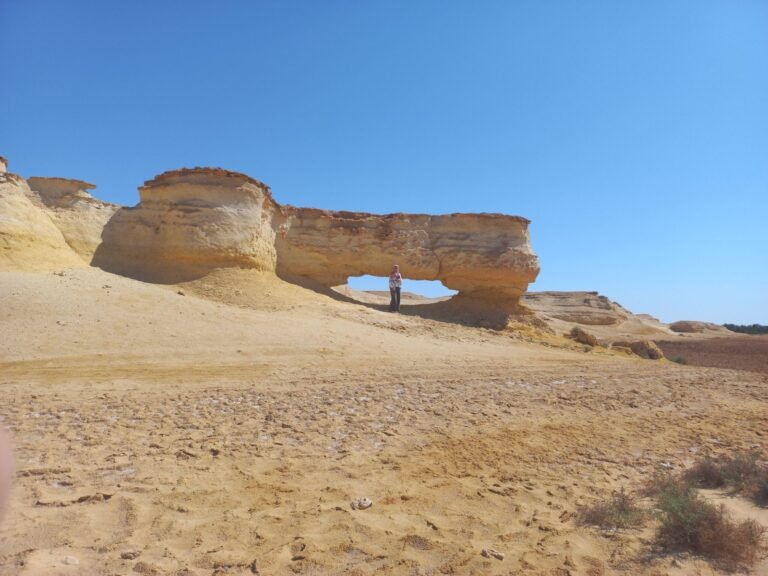
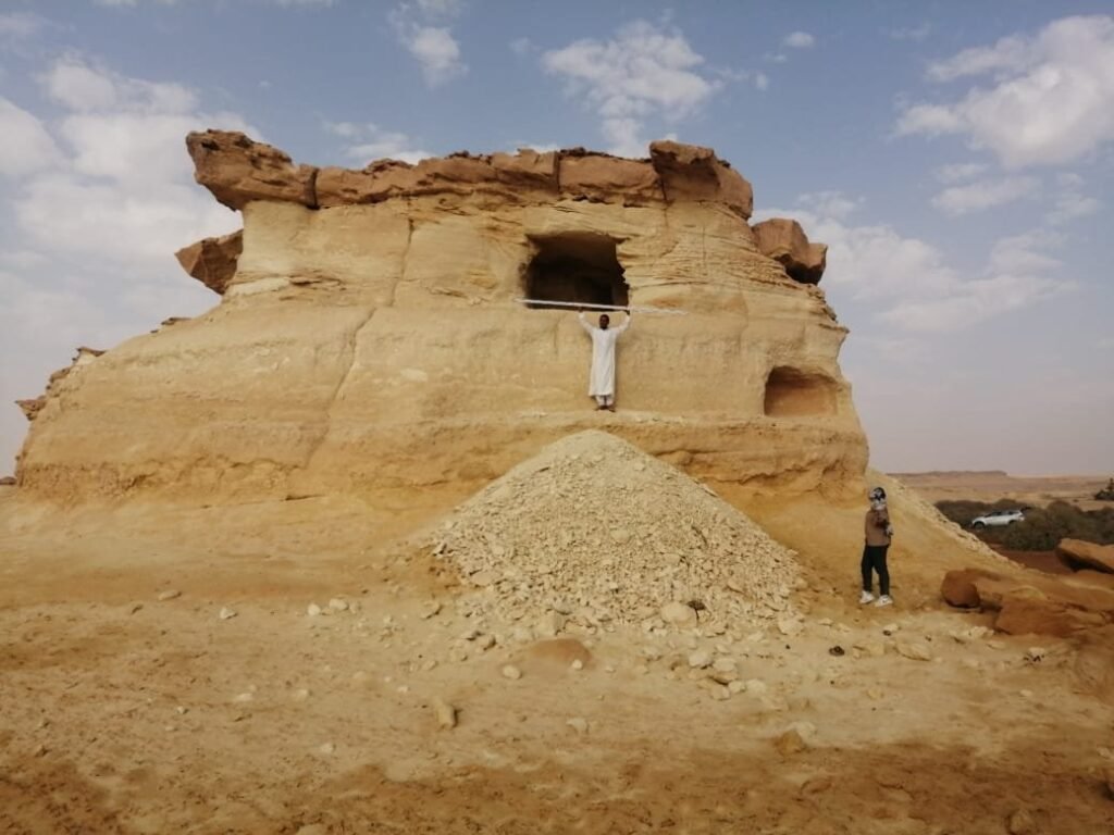
A natural bridge formed as a result of wind erosion in horizontal sedimentary layers north of Gara Umm al-Saghir (Photo: Magdy TORAB)
It is the most dominating sand mound in this dune-field and is considered a particularly attractive geomorphological feature of this region. Its presence west of the oasis desert may act as a barrier protecting the oasis from sand drifting. Wind, in this area, primarily develops a series of linear and branching sand ridges in a northeasterly and westerly directions. The utmost height of the sand-sea surrounding Siwa is about 300 ms, descending gradually to the Mediterranean Sea level.
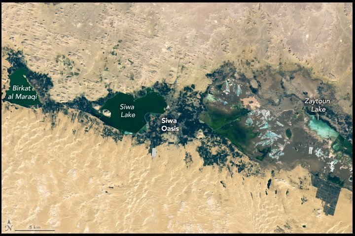
Oasis lakes are important geomorphological landscape features of Siwa, and they support local hydrology, biology, and the human economy. The lakes also advocate the convergence of the local environment with the associated issues. It is important to study the formation characteristics and environmental significance of the Siwan Oasis lakes.
Geomorphology of Siwa Oasis (After: Hussein, 2021)
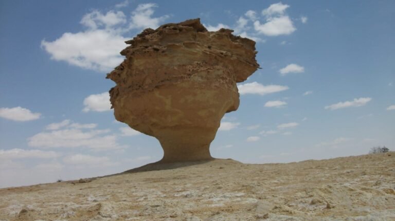
Mushroom’s hill remains sculpted by the wind north of the Gara of Umm al-Saghir (Photo: Noura FAYAD).
Climate
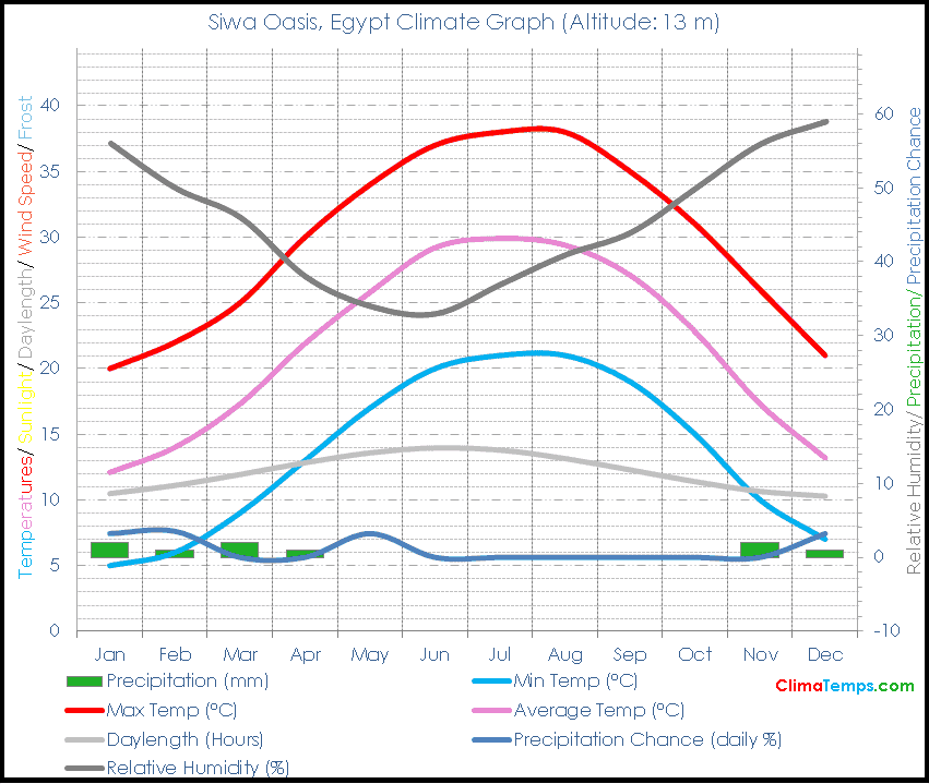
Its climate is generally continental; cold winters and hot summers, while being relatively mild in both spring and autumn. Therefore, the best time to visit Siwa is in the spring or autumn, when the locals hold their celebrations and the weather is mild.
Climate graph of Siwa Oasis (After: www.climatemps.com)
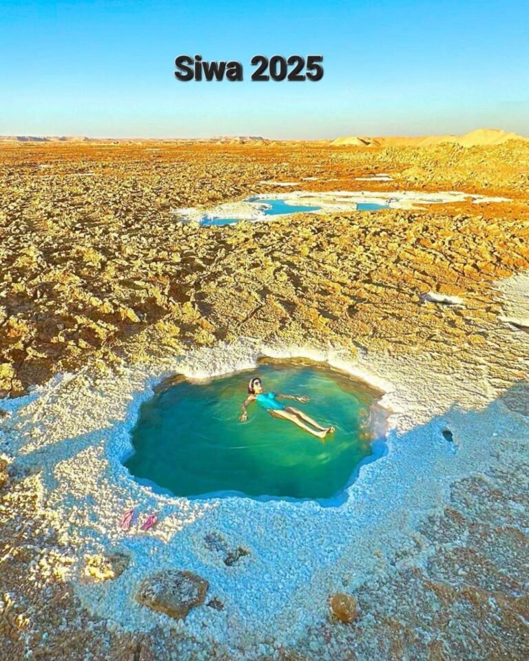
A pond formed by the emergence of a natural spring on the margins of the Great Sand Sea, south of the Siwa Oasis (Photo: https://beta.sis.gov.eg/)
Archaeology
Siwa Oasis is one of Egypt's most prominent natural reserves and unique archaeological locations, representing an important model for a closed ecosystem that the state strives to protect against degradation. Covering an area of 7,800 km², it has been decreed by the government as a natural reservation. Home to various types of animals and plant life, the area includes four major lakes, numerous wells and springs used for irrigation, drinking and therapeutic purposes. Several archaeologically significant sites have also been defined as well, such as the Tombs of the Mountain of the Dead and the Temple of Amun, which witnesses the phenomenon of the spring equinox twice a year.
Geosites
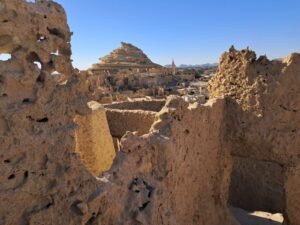
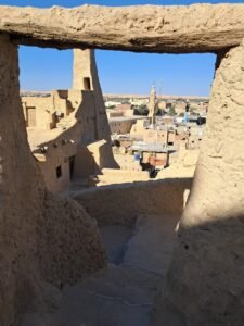
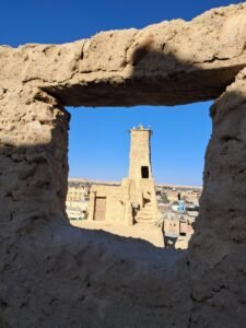
Fortress of Shali:
Central Siwa is dominated by the spectacular organic shapes of the remains of this 13th-century mud-brick fortress. Built from kershef (chunks of salt from the lake just outside town, mixed with rock and plastered in local clay), the labyrinth of huddled buildings was originally four or five stores high and housed hundreds of people. A path leads over the slumping remnants, past the Old Mosque with its chimney-shaped minaret, to the top for panoramic views.
A conical mound left by erosion photographed from Fortress of Shali (Photo: Magdy TORAB)
Interior views inside Fortress of Shali
(Photos: Magdy TORAB)
El-Dakrur Mountain
is located in the north with a series of adjacent hills such as the triple-peaked Nadra and Nazara Summits composed of shale, carbonate and clay layers. Its famous hot sands stretch 3 km southwest of the Siwa Oasis and is visible from all sites in the oasis. This location could be reached from the city through the asphalt Siwah-El Dakrur road. Palm trees and Birket Aghourmy form the scenery in this the site. The sandy plains are used for medicinal recuperation during the moths of July and August. Tourist camps, along with local houses, farms, and lakes are all present on the mountain slopes.
Gebel El-Mawta
(Mountain of the Dead) is one of the most significant archaeological discoveries in the entire Western Desert. It shows that ancient civilizations of different denominations (Pharaonic, Roman) have long identified and accordingly utilized Siwa Oasis, and that it has always been a significant spot of interest to Egyptians up to its current re-denomination as a reservation. Ancient Egyptians were buried in tombs curved inside the mountain from top to bottom according to social rank. Rulers occupied the top portion of the mountain followed by the rich and then the ordinary gradually to the bottom. The mountain is largely composed of calcareous rocks at approximately 500 m above sea level. It is home to 1,000 tombs and caverns structured around an intricate network of tunnels resembling beehives with numerous dug spots and holes. It also contains numerous intricately built catacombs forming geometric patterns of regular succeeding rows.
General view for Gebel El-Mawta (Mount of the Dead (Photo: SPA/)
The depression includes
remarkable geo-sites such as the lake of Maraqi, three islands, springs at Bahi El-Deen, Ain Bandi Spring, Ain Abd ElGabar, mountains and plateaus. Current local villages still utilize ancient agricultural methods offering rich geological, paleontological and archaeological interests for researchers the world over.
The depression includes
several natural springs such as the famous Tamakart, Cleopatra, Fatnas, and Alaryas. It also has sand baths and mountains such as Gabal El Dakrur and Gabal El Mawta in addition to many salt-lakes such the main Siwa Lake. The Fatnas Island is another attraction formed by a collection of naturally occurring gardens located downtown Siwa. Salt Lakes are generally regarded as naturally healing spots for medical
tourism located 4 kms west of the main Siwa depression. Swimming for medical recuperation is quite safe in these lakes due to the high buoyancy their waters extreme salinity
Cleopatra's natural spring (Photo: SPA)
Qureishet depression
includes farmlands, mountains, mesas, plateaus and springs such as Ain Qureishet and the Zeitoun Lake ideal for hiking, camping and other outdoor touristy activities.
Abu Shrouf
is a depression surrounded by mountains and plateaus with farmlands and springs such as Ain Abu Shrouf quite welcoming of outdoor activities.
Birket Maraqi
includes several islands, mountains, plateaus and is surrounded by farmlands houses, several mountains, plateaus, and hills. It offers rich geological, paleontological and archaeological sites.
Birket Siwa
is a depression full of water fed by the surrounding mountains, plateaus and hills.
Lakes of Siwa Oasis (Google earth)
Great Sand Sea
is located in the Sahara between Western Egypt and Eastern Libya in North Africa. 74% of the area was covered by sand dunes with hills and mountains. Cold, fresh water lake is also available for swimming with springs supplying drinking water. It is famous for its ‘Zarda’ ‘Siwan tea’ and local Siwan foods.
Great Sand Sea (Photo: SPA)
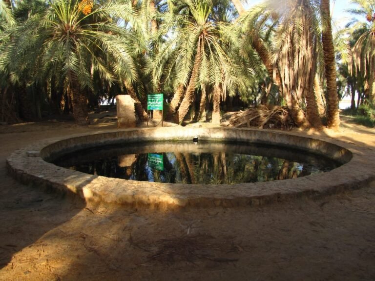
Natural springs;
there are more than 1500 natural cold and hot springs in the oasis. They have been used since Ancient Egyptian and Roman times. Many are located a few meters below the land surface. These springs (such as Cleopatra, Fatnas and Alaryas) are famous for their healing powers.
Gara Oasis
The Qara Oasis (Gara or Qara Umm El Saghir Oasis) is located on the western edge of the Qat¬tara Depression (Farouk et al., 2010), 198 kms south of the city of Marsa Matrouh, and 120 kms northeast of the Siwa Depression. Qara can be considered the most isolated of all Egyptian oases. It might be said that human civilization has to some extent affected the other oases, while Gara maintains its uniqueness in this regard. It has its own Shali (historical fort) and natural springs. Few people make it to Gara, so locals are always enthusiastic to see visitors. Children are particularly excited, so you may wish to carry small gifts. Qara is sometimes known as the camp of Alexander The Great, because, on his return journey from Siwa to the ancient city of Memphis, he paused here for a while. Numerous other notable locations are bound to enrich academic as well as touristy experiences.
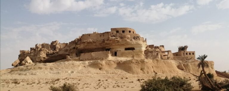
Ruins of the village of Gara Umm al-Saghir (Photo: Magdy TORAB)
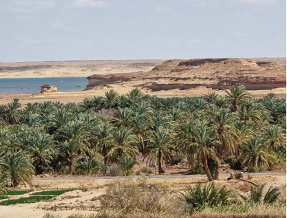
Plam trees and lake east of Gara Umm al-Saghir (Photo: Noura FAYAD)
Plam trees and lake east of Gara Umm al-Saghir (Photo: Noura FAYAD)
Location of Gara Oasis (After: Gobashy et al., 2021)
References
Ahmed, E. A. (2023). Assessment of the geosites and geodiversity in the prospective geopark in Siwa in the Western Desert of Egypt. International Journal of Geoheritage and Parks. Volume 11, Issue 1, March 2023, Pages 182-201
CONOCO, & Egyptian General Petroleum Corporation EGPC., (1987). Geological map of Egypt. Scale, 1(500), 000.
Embabi, N.S. (2004). The geomorphology of Egypt: Landforms and evolution Egyptian Geographical Society, Cairo
Hussein, M.S., (2021). An “out-of-the-depression” drainage solution to the land degradation problem in Siwa Oasis, Egypt. Arab J Geosci 14, 740.
Gobashy, M.M., Metwally, A.M., Abdelazeem, M., (2021). Geophysical Exploration of Shallow Groundwater Aquifers in Arid Regions: A Case Study of Siwa Oasis, Egypt. Nat Resour Res 30, 3355–3384.
Fayad, N.H., (2023). Karst landscape morphology of Qarat Umm Al-Saghir Area, Western Desert of Egypt [MsC thesis]. University of Primorska, 187 pp.